Problem
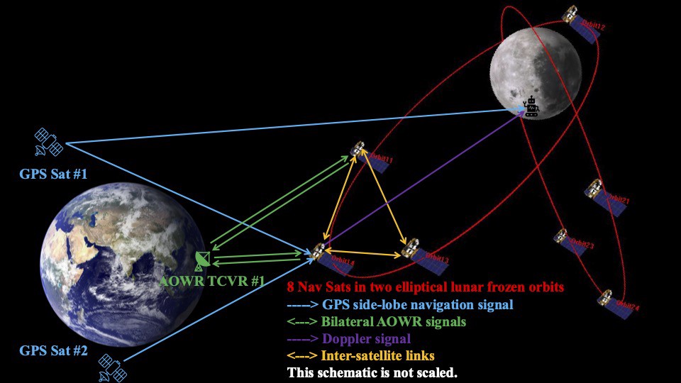
Beyond geostationary orbit, Earth GNSS signals arrive weak, sparse and from a poor geometry; ground tracking is a scarce, contested resource with light-time delay attached; and the lunar south pole — where the missions are going — is among the hardest regions to cover. Without an architecture that holds accuracy autonomously, every landing, rendezvous and surface operation waits on a deep-space tracking slot.
Capability
My research group design navigation architectures for cislunar space and evaluate what accuracy they can sustain, treating constellation geometry, inter-satellite links and time synchronisation as one coupled problem rather than three. The estimation work underneath: higher-order and square-root unscented estimators, factor graph optimisation for orbit determination and time synchronisation, and station-keeping models that make long-horizon constellation studies tractable.
Demonstrated result
- Autonomous orbit determination to approximately 11 m in 3-D position and 1.58 mm/s in velocity using one-way range and range-rate inter-satellite links between three evenly phased relay satellites in distant retrograde orbits and navigation satellites in elliptical lunar frozen orbits, with no direct ground support to the navigation satellite (CR3BP case). Under a high-fidelity dynamical model, a two-day initial ground-tracking handover followed by inter-satellite tracking alone yielded approximately 1 km in position and 10 mm/s in velocity. Validated with Monte Carlo runs and NEES/NIS consistency checks. Enbai Ji, MPhil thesis, UNSW Sydney, 2025: Autonomous Orbit Determination of Lunar Navigation Satellites Based on Inter-Satellite Links.
- A lunar navigation constellation optimised for targeted south-pole coverage, combining high-fidelity propagation, a semi-analytical station-keeping model and Earth-GPS integration for time synchronisation and ephemeris generation. Rameez A. Malik and Yang Yang, Lunar navigation system optimization for targeted coverage with semi-analytical station keeping model and Earth-GPS integration, Acta Astronautica 239, 278–293 (February 2026).
- HALO, a high-precision analyser for lunar orbits, presented at the Australian Space Research Conference (slides).
- Factor graph optimisation for lunar orbit determination and time synchronisation, presented in the Lunar Navigation session at PNT 2026.
External use
The work is funded as ARC Discovery Project DP260100821 with Professor Andrew Dempster (UNSW ACSER, lead chief investigator) and Professor Junichiro Kawaguchi. Its stated outcomes — single-satellite Doppler positioning deployable ahead of full PNT infrastructure, autonomous on-board positioning, and time synchronisation for lunar PNT satellites — are targeted at Australia’s robotic lunar mission and at Australia’s national lunar PNT capability.
Next partnership opportunity
A cislunar and lunar PNT trade study on your mission geometry: a coverage and accuracy budget across the regimes you nominate, and an architecture recommendation with every assumption written down. See Partner with us.